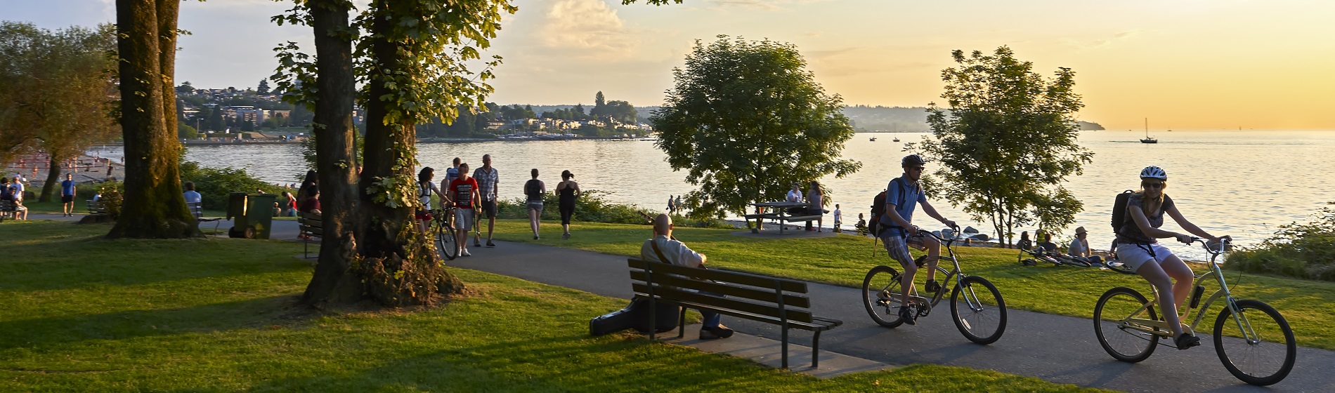
Welcome to the Trail Capital of Canada! The Township of Uxbridge has over three hundred kilometers of trails running through our historic communities and rural forested lands. Explore our trail maps and plan a hike today.
The Trans Canada Trail (formerly Great Trail)
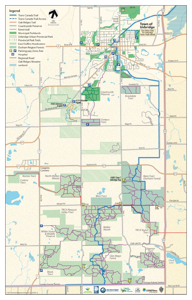
The Trans Canada Trail is a recreational trail that winds across the country through every province and territory. The trail enters Uxbridge via an abandoned rail line from Lindsay. The trail then crosses the Uxbridge urban area, then heads south through Durham Forest lands, the Glen Major Forest and to the Uxbridge-Pickering Townline.
Uxbridge Town Trail System
Welcome to the Uxbridge Town Trail System, a captivating network of pathways nestled within the urban landscape, seamlessly connecting to prominent trails to the south, such as the Trans-Canada Trail, Durham Forest and the Oak Ridges Trail. This extensive network offers a range of outdoor experiences that cater to diverse interests and preferences.
The Uxbridge Town Trail system is a collaborative effort between the Township of Uxbridge and dedicated volunteer groups. This partnership reflects our commitment to providing enriching recreational opportunities for residents and visitors alike. Our trails are meticulously maintained by an enthusiastic team of Volunteers and Trail Staff, ensuring your safety and enjoyment as you explore the natural beauty and historical charm of Uxbridge.
As you journey along these trails, you'll find insights into the rich history of our town. Historical information has been graciously provided by the Uxbridge Historical Centre, offering a glimpse into the past that enhances your trail experience.
Before embarking on your adventure, we encourage you to review our Trail Safety Tips. Your safety is paramount, and these guidelines are designed to help you make the most of your trail exploration while staying mindful of your well-being.
Discover the Uxbridge Town Trail system—a testament to community collaboration, natural splendor, and the spirit of exploration. Whether you're walking, running, cycling, or engaging in winter activities, the trails are here to welcome you into the heart of our town's unique tapestry. Enjoy your journey!
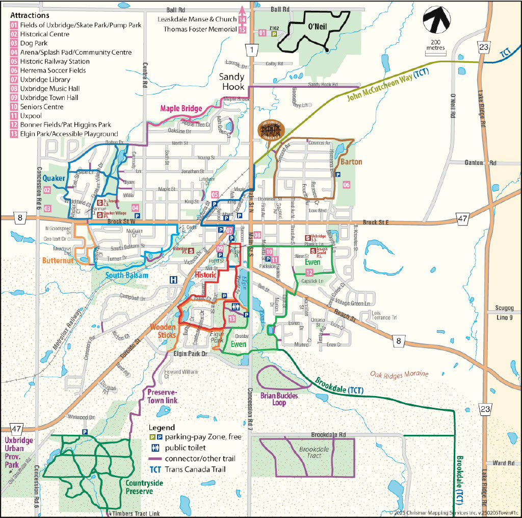
| Barton Trail |
|
View the Barton Trail Map to find the trail access and route.
Length: 2 km, a loop trail Level of Difficulty: Easy Activities: Cycling, Dog Walking, Walking/Running, Cross Country Skiing, Snowshoeing Amenities: Parking, Picnic Table Accessibility: Partial Wheelchair Access Surface: Asphalt, Grass/Natural Trail System: Uxbridge Town Trails Entrance locations (s) and Parking Info: Herrema Park/Fields at 85 Herrema Blvd, Uxbridge, ON L9P 1W6. Distance from Herrema Park/Fields to Trestle Bridge: 1 km one way. Wayfinding Posts: All Wayfinding posts are oriented northward and feature a trail map, post numbers, and a 'you are here' indicator. Trail Description: Barton Trail circles the Barton Farms community and passes by Herrema Fields with its playground and covered picnic area, through the residential streets, along woodland sections, and by a pond. Complete the loop from Herrema Fields to the Trestle Bridge, along the Trans Canada Trail, and back to Herrema Fields. You can also access the Trans Canada Trail for a long journey along the old railway track, which continues north of Uxbridge. Find out more about the Trans Canada Trail / John McCutcheon Way and the Trestle Bridge. |
| Brookdale Trail |
|
View the Brookdale Trail Map to find the trail access and learn more about the trail route and features.
Length: 3.7 km Level of Difficulty: Advanced; steep hills and narrow turns Activities: Dog Walking, Hiking, Horseback Riding, Mountain Biking Snowshoeing, Walking/Running Amenities: No Amenities Accessibility: No Wheelchair Access Surface: Grass/Natural Soil Compacted Trail System: Trans Canada Trail, Uxbridge Town Trails Entrance Location(s) and Parking Info: Parking off Elgin Park Drive (Elgin Park entrance) and use the Ewen trail traveling East to reach the Brookdale Trails Trail crosses Main Street South (7th Concession) Wayfinding Posts: All Wayfinding posts are oriented northward and feature a trail map, post numbers, and a 'you are here' indicator. Trail Description: The Brookdale Trail is a town trail that runs alongside the Trans Canada Trail system, offering users a scenic journey through the forest. This off-road trail is perfect for activities like snowshoeing, mountain biking, and cross-country skiing, thanks to its well-packed footing. Expect some challenging sections with steep climbs, but the trail rewards you with beautiful views, a bridge, and boardwalk crossings. Please be aware that the portion off Brookdale Road is frequently used by horseback riders, so exercise caution while sharing the trail. |
| Butternut Trail |
|
View the Butternut Trail Map to discover the trail access and get more details about the route.
Length: 1.5 km Level of Difficulty: Easy, Suitable for all levels of mobility, including mobility scooters, the trail primarily consists of a paved surface, with occasional packed unpaved sections near the pond and some moderate inclines. Activities: Cycling, Dog Walking, Walking/Running Accessibility: Complete Wheelchair Access Surface: Asphalt Trail System: Uxbridge Town Trails Entrance Location(s) and Parking Info: A parking lot is situated at a distance from the trail. The suggested parking spot is Uxbridge Arena at 1-291 Brock St W, Uxbridge ON L9P1G1 Wayfinding Posts: All Wayfinding posts are oriented northward and feature a trail map, post numbers, and a 'you are here' indicator. Trail Description: The pathways throughout the area are mostly paved, with the exception of the section encircling the pond. If you wish to embark on a longer route, there are connections that lead south to the South Balsam Trail (refer to the map) and north to the Quaker Trail. During your journey, you will traverse residential areas, including the original farm homestead, which has been seamlessly integrated into the development. Keep an eye out for the magnificent Butternut tree, from which the development derives its name. Until recently, this area remained farmland since its earliest settlement. The land was first owned by Dr. Allan Beswick in 1805. The old homestead (refer to the map) dates back to 1859 and was inhabited by members of the founding Gould family, much like many of the oldest houses in Uxbridge. The barn, constructed in 1896 by Isaac Gould, remains a testament to the area's rich history. Originally, the house consisted solely of the current back section, built using stacked hemlock timbers. In the 1890s, the front section was relocated from the vicinity of the Anglican Church. From 1913 to 1968, the Forsythe family tended to the land as farmers. Carol and Wain Trotter acquired the house and surrounding acreage in 1982, raising sheep there until 2004, when the present development began. Standing proudly next to the farmhouse is the ancient butternut tree, which lends its name to the community. The creation of the Butternut Trail has been made possible through the generous sponsorship of Alliance Homes Inc. and Butternut Manor Uxbridge Inc. |
| Countryside Preserve and Trail Links Maps |
|
View the Countryside Preserve Trail Map to find the trail access and plan your route. Below are also included the Preserve-Town Link Map (access to the Preserve from the north) and the Timbers Tract Link Map (access to the Preserve from the south).
Length: 9 km Level of Difficulty: Easy, Moderate Activities: Dog Walking, Hiking, Snowshoeing, Walking/Running X-Country Skiing Amenities: Benches, Parking Accessibility: No Wheelchair Access Surface: Asphalt, Grass/Natural, Soil Compacted Trail System: Uxbridge Town Trails Entrance Location(s) and Parking Info: The parking lot and trail head for the Countryside Preserve is located just behind Walmart in Uxbridge (6 Welwood Drive). Wayfinding Posts: All Wayfinding posts are oriented northward and feature a trail map, post numbers, and a 'you are here' indicator. Trail Description: Welcome to the Uxbridge Countryside Preserve, spanning 140 acres of picturesque rolling meadowland, woodlands, wetlands, and ponds. As you embark on your journey through the Preserve, you'll encounter art pedestals, interpretive ecology displays, and a rich array of local flora and fauna along the extensive nine-kilometre trail network. Families can delight in three nature-inspired, kid-friendly trail loops featuring frogs, butterflies, and birds. Situated on the Oak Ridges Moraine, a protected area classified as a 'core' in the Provincial Moraine Plan, the Countryside Preserve showcases the highest concentration of vital natural heritage features. Conveniently located just south of Uxbridge's urban boundary, behind the prominent shopping complex on Highway 47 at Concession 6, it serves as a harmonious meeting point between the countryside and town. It is truly “Where the Countryside meets the Town”. Note: There is a small section of the Countryside Preserve Trail System which is shared with the Heart of Ontario Snowmobile Club during the winter season. Countryside Link Maps:The Countryside Preserve offers connectivity to other trails, including Wooden Sticks and Timber Tract, expanding your exploration options and outdoor experiences. These trails are reflected in the Link Maps shown below. Preserve-Town Link Map Timbers Tract Link Map
|
| Ewen Trail |
|
View the Ewen Trail Map to discover the trail access and get more details about the trail route.
Length: 3.4 km Level of Difficulty: Moderate. The trail is generally easy, with some moderate slopes. Activities: Cycling, Dog Walking, Walking/Running, Snowshoeing, Cross-Country Skiing Accessibility: Partial Wheelchair Access Surface: Asphalt, Grass/Natural, Gravel, Soil Compacted Trail System: Uxbridge Town Trails Entrance Location(s) and Parking Info: Elgin Park (180 Main St. S) and Bonner Fields (21 Capstick Lane) Wayfinding Posts: All Wayfinding posts are oriented northward and feature a trail map, post numbers, and a 'you are here' indicator. Trail Description: The Ewen Trail covers a variety of countryside and urban scenery in a 3.4km loop. It includes three ponds, a section through Elgin Park, a route through thickly wooded areas, and a walk along streets containing some of Uxbridge's most historic homes. The trail winds through a wooded section at the south end of Elgin Park, then along a delightful grassy path and around Bass Pond (yes, there are bass in it), which is a stormwater holding pond for the Wooden Sticks area. Enjoy the history and educational plaques as you walk this trail. Elgin Park is Uxbridge's main municipal park, where there are public washrooms and a play area for children close to the trail route. Enjoy the wonderful addition of an inclusive play area donated by The Lion's Club of Uxbridge. The history of Elgin Park goes back to the 1860s when folk from the hamlet of Uxbridge went for picnics in what was then known as the "South Woods". It became a public park in 1873, named after Lord Elgin, James Bruce, Governor General of Canada from 1846-54. More land was purchased in 1877 and 1888 to enlarge the park, and a half-mile racetrack was built in 1881. In 1876, a campaign picnic in connection with a byelection in the area was addressed by Sir John A. Macdonald; it was so successful that he organized similar picnics elsewhere and won the byelection. A picturesque park has been established around another holding pond at the foot of Ewen Drive, with benches where you can relax. This whole area was farmed by the Ewen family (Rae and Marion) in the mid-1900s. Hence the names of Ewen Drive and Marion Drive. Capstick Lane, named after Lloyd Capstick, a local barber for many years who was named Citizen of the Year in 1992 for his many volunteer activities. Bonner Fields, named to honor Brent Bonner, an ardent sports lover and coach, who died in a car accident in 2003. The Jumpstart Inclusive Multi-Sport Court has been generously donated by Canadian Tire Jumpstart Charities and the local Uxbridge Canadian Tire Jumpstart Charity. The multi-sport court is part of the Jumpstart Charities' Inclusive Play project, which focuses on inclusive infrastructure and programming to help give Canadian kids of all abilities access to sport and play. Third Avenue towards Planks Lane, you will see two streets of "wartime housing" at the southeast corner, built in the late 1940s. Note the lack of roof overhangs, etc. as a saving on materials. Along Planks Lane are some of Uxbridge's fine old houses, many from the 1800s. Planks Lane is named after John Plank who acquired 100 acres there around 1825. He built a tavern across from the present Music Hall, and sold lots to many businesses, making the street the main street (hence the name) of the town at that time. Main Street, note the third house on the east side. It was originally built as a Methodist Episcopal Church on Bascom St. and was moved to its present location in 1878. It became the Free Methodist Church and was closed as a church in 1976 when a new Free Methodist Church was built on Reach Road. Notice that the house still retains the look of a church. Note: the route through the park is closed four times a year for major events (Fall Fair, Highland Games, etc.). |
| Historic Trail |
|
View the Historical Trial Map to find the trail access and learn more about the trail features.
Length: 2.5 km Level of Difficulty: Easy Activities: Cycling, Dog Walking, Walking/Running Amenities: Benches, Parking, Picnic Tables, Washroom Accessibility: Partial Wheelchair Access Surface: Asphalt, Grass/Natural Trail System: Uxbridge Town Trails Entrance Location(s) and Parking Info: Parking is available at Centennial Park (1 Centennial Dr.) & Elgin Park (180 Main St. S). Wayfinding Posts: All wayfinding posts are oriented northward and feature a trail map, post numbers, and a 'you are here' indicator. Trail Description: The Historic Trail connects with Wooden Sticks, Ewen Trail, and part of the Trans-Canada Trail. The Historic Trail winds through the oldest part of Uxbridge with a 'Rotary Lookout' deck over Elgin Pond. The feature of this trail is the series of six historical information plaques that describe Uxbridge life in "the old days" and illustrate what the town looked like, using old photographs and maps. The trail is mostly on paved streets but has a small section around the Wooden Sticks Retention Pond that may be unsuitable for scooters and wheelchairs. However, many of the historical information plaques are on streets and universally accessible. Elgin Park now has a wonderful, paved connector path which connects the trail from Joseph St. into the Park, making it even more accessible. Parking at Centennial Park starts you on this trail's journey past the Trans-Canada Trail Pavilion and through the Ruth Cooper Bird Sanctuary (note the plaque). The trail crosses over a stream and travels south on Pond Street, then turns right at Mill Street. Centennial Park was part of Uxbridge's original pond, which was no longer needed for waterpower by the late 1940s. By that time, it had reverted to being a creek, and the pond bottom became the town's dump. As a Centennial project in 1967, the former pond site and dump became Centennial Park. A historical information plaque tells the story of the Electric Light Pond – how it got its name, and pictures and history of the old mill and later electricity generating station that was driven by water from the pond. As you'll see, this area was out in the country, where the highway (now Durham Highway 47) was a gravel road.) Elgin Park historical information plaque shows pictures of the park from the early years of the last century, including its use as a harness racing track. The history of the park is described, going back to the 1860s. A lookout provided by the Rotary Club for a good view north up the length of the pond. There's a picnic table there, as well as a historical information plaque giving information about Elgin Pond — why it was formed and how it provided much of the waterpower on which early industry in Uxbridge was based. Water St. contains some fine old houses from the late 19th Century. The Historic Trail was created as a project of the Rotary Club of Uxbridge, to mark the 100th anniversary of the founding of Rotary International. Generous support also came from the Uxbridge-Scott Historical Society. |
| John McCutcheon Way / Trans Canada Trail (Trestle Bridge Trail) |
|
View the John McCutcheon Way Map to find the trail access and learn more about the trail route and features.
Length: 2.5 km Level of Difficulty: Easy Activities: Cycling Dog, Walking, Hiking, Mountain Biking, Snowshoeing, Walking/Running, X-Country Skiing Accessibility: No Wheelchair Access Surface: Gravel Trail System: Uxbridge Town Trails, Trans Canada Trail Entrance Location(s) and Parking Info: Park at the York Durham Heritage Railway on Railway Street, where you can truly experience the history of the Train, the Trestle, and the Witches hat roof at the Historic Railway station. Follow the Trans Canada Trail and Trestle Bridge signs to the entrance of John McCutcheon Way. Alternately, park at Herrema Soccer Fields at 85 Herrema Blvd and follow the Barton Trail to access John McCutcheon Way, part of the Trans Canada Trail. Trail Description: The Trestle Bridge Trail offers a unique historical experience as it takes you across the iconic Uxbridge Trestle Bridge, originally built in 1872 by the Toronto-Nipissing Railway. This well-maintained rail trail is flat and easy to navigate, making it suitable for various outdoor activities such as hiking, mountain biking, cycling, and cross-country skiing. The Trestle Bridge itself is a testament to the area's railway history, having carried the weight of trains transporting wood and grain from northern Ontario to Toronto. Today, it offers a safe passage for trail users, providing panoramic views of the surrounding natural beauty. As you continue along the Barton Trail, which follows the historic rail-bed, you walk in the footsteps of railroad workers and settlers who played a significant role in making Uxbridge a major railroad hub over a hundred years ago. The trail is named after John McCutcheon, a dedicated resident who, in collaboration with Trans Canada Trail Pan Am / Parapan Am Legacy funds, contributed to the restoration of the Trestle Bridge. The Trestle Bridge Trail offers a leisurely outdoor experience while allowing you to connect with Uxbridge's rich railway heritage and natural landscapes. Whether you're walking, cycling, or skiing, this trail provides a scenic and historical journey for all to enjoy. Note: John McCutcheon Way is shared with the Heart of Ontario Snowmobile Club during the winter season. |
| Kettle Pond Trail |
|
View the Kettle Pond Trail Map to find the trail access and learn more about the trail route and features.
Length: 1.1 km Level of Difficulty: Easy Activities: Dog Walking, Hiking, Mountain Biking, Snowshoeing, Walking/Running, X-Country Skiing Amenities: Parking Accessibility: Partial Wheelchair Access Surface: Asphalt, Gravel Trail System: Uxbridge Town Trail Entrance locations (s) and Parking Info: Goodwood Community Hall (268 Durham Regional Highway 47, Goodwood, Ontario, L0C 1A0) Wayfinding Posts: Wayfinding posts all face north with a map of the trail and post numbers with a 'you are here' indicator. Trail Description: This trail is a hidden gem, tucked behind the Township of Uxbridge’s Goodwood Community Hall. A great walk to hear and see a variety of birds. An open trail that offers a quiet, peaceful walk-in nature. |
| Maple Bridge Trail |
|
View the Maple Bridge Trail Map to find the trail access and learn more about the features.
Length: 1.5 km Level of Difficulty: Easy Activities: Dog Walking, Hiking, Snowshoeing, Walking/Running, X-Country Skiing Accessibility: Partial Wheelchair Access Surface: Grass/Natural, Gravel, Soil Compacted Trail System: Uxbridge Town Trails Entrance Location(s) and Parking Info: Park at the curve of Maple Brook and Oakside Dr. to enter at wayfinder post MB1 Wayfinding Posts: All wayfinding posts are oriented northward and feature a trail map, post numbers, and a 'you are here' indicator. Trail Description: The Maple Bridge Trail is sponsored by Mason Homes. It runs along the path of a stream, through lush woodlands with two wooden bridges and farm field scenery. It is a single path (no loop) with a crushed stone base and has an easy connection to the Quaker Trail. Note: A section of this trail has an abundance of ants. |
| O'Neil Trail |
|
View the O'Neil Trail Map to find the trail access and learn more about the trail route and features.
Length: 2.4 km Level of Difficulty: Easy Activities: Dog Walking, Hiking, Mountain Biking, Snowshoeing, Walking/Running, X-Country Skiing Amenities: Parking Accessibility: Not Wheelchair Accessible Surface: Grass/Natural Compact Soil Trail System: Uxbridge Town Trail Entrance locations (s) and Parking Info: Permit Parking is available at the Fields Of Uxbridge Parking Lot (Durham Regional Rd, 355 Main St N #1, Uxbridge ON.) Wayfinding Posts: Wayfinding posts all face north with a map of the trail and post numbers with a 'you are here' indicator. Trail Description: The O'Neil Trail is a combination of natural grassy areas and a beautiful, wooded section. The scenic wooded area leads to an idyllic view of the Uxbridge Brook, and will take you around the soccer fields of Uxbridge. This trail is an enjoyable easy walk. The trail is named after Uxbridge Resident Michael O'Neil, a local farmer and blacksmith, who owned the property in the area. |
| Quaker Trail |
|
View the Quaker Trail Map to find the trail access and learn more about the trail route and features.
Length: 3 km Level of Difficulty: Moderate Activities: Dog Walking, Hiking, Mountain Biking, Walking/Running, Snowshoeing, Cross Country Skiing Amenities: Benches, Parking Accessibility: Partial Wheelchair Access Surface: Asphalt, Grass/Natural, Gravel, Soil Compacted Trail System: Uxbridge Town Trails Entrance Location(s) and Parking Info: The trail may be entered from a number of access points. The main parking is available at the Uxbridge Historical Centre (7239 Concession Rd. 6), or alternately at the Uxbridge Arena at 291 Brock St W, Uxbridge ON L9P1G1. This trail can be accessed from many locations. Wayfinding Posts: Wayfinding posts all face north with a map of the trail and post numbers with a 'you are here' indicator. Trail Description: Is designed as a loop, has loops within the loop, and can be accessed from many locations. The Quaker Trail begins its journey at the Uxbridge Historical Centre and winds its way down and around the Quaker Village residential area in northwest Uxbridge. It passes through some of the most historic areas of the town's past and accesses the Uxbridge Historical Centre. The Uxbridge Historical Centre is a treasure trove of information and artifacts relating to Uxbridge's past when it was a small but thriving hamlet. The Historical Centre is the site of the first school in the township, a log building built in 1817. This was replaced by a frame schoolhouse, which was in turn replaced by a brick building (1924), which now stands in the museum "village." There are also displays depicting three prominent residents: Lucy Maud Montgomery, who wrote the "Anne of Green Gables" children's books; Glenn Gould, world-renowned pianist, and artist David Milne. Picnic tables are available on the grounds, and lots of room for kids to play. This area was where Joseph Gould, one of Uxbridge's pioneers, built his home. The Gould family owned all the land covered by the trail and sold parts of it in 1914 to the Carmody family, who farmed the land until selling it in 1952. It continued to be used as pastureland until the 1980s when the Quaker Village development started. Note the "Carmody" name on a nearby street. The Quaker Common Pond is man-made, designed as a storm-water runoff pond to contain rainwater drainage from the entire Quaker Village area. The pond has developed into a natural wetland area, with blue herons, many other bird species, and many species of fish, including bluegill, perch, sunfish, and largemouth bass. A large snapping turtle also makes his home there. Finally... who is this, Colonel Sharpe? Sam Sharpe (born 1872) was a prominent lawyer and Member of Parliament who raised a local regiment to fight in World War I. He became sick overseas and returned to Canada in 1918. He never made it home to Uxbridge but died in Montreal. Other street names: Rachel Lee was Joseph Gould's mother, and Milne Court is named after artist David Milne, who lived and worked in an upstairs apartment on Brock Street for many years. Note: This trail connects easily with 3 other town trails, Maple Bridge, South Balsam, and Butternut Trails. |
| South Balsam Trail |
|
View the South Balsam Trail Map to find the trail access and learn more about the trail route and features.
Length: 3 km Level of Difficulty: Moderate Activities: Dog Walking, Hiking, Mountain Biking, Walking/Running Amenities: Benches, Parking Accessibility: Partial Wheelchair Access Surface: Asphalt, Grass/Natural, Gravel, Compacted Soil Trail System: Uxbridge Town Trails Entrance Location(s) and Parking Info: Parking is available at the Uxbridge Arena 291 Brock St W, Uxbridge ON L9P1G1). Wayfinding Posts: Wayfinding posts all face north with a map of the trail and post numbers with a 'you are here' indicator. Trail Description: The South Balsam Trail offers a delightful outdoor experience, suitable for various activities including walking, running, cycling, and even winter activities like snowshoeing and cross-country skiing. The trail covers approximately 3 kilometers and presents a moderate level of challenge due to its length and diverse terrains. Around half of the trail meanders through thick, old-growth forests and newly reforested fields, providing a peaceful and serene ambiance. The other half of the trail navigates through town streets, offering a blend of natural beauty and urban surroundings. Identification plaques featuring information about specimen trees enhance the trail's educational aspect. These plaques can be particularly instructive for walkers and school field trips, contributing to a deeper understanding of the local ecosystem. The trail's history intertwines with the Collins family, who purchased land from Dr. Beswick. John Collins, known for his protective attitude toward his woods, likely contributed to the survival of much of the original forest in the area. A historical note from 1840, found in the Uxbridge Historical Centre, highlights John Collins' commitment to preserving timber resources. Forsythe Drive takes its name from the family that acquired a significant portion of the land in this area around 1915. The history of the region dates back to 1805 when the Crown granted the land to Dr. Christopher Beswick. Although he wasn't a Quaker, Dr. Beswick's journey took him from Catawissa, Pennsylvania, to Uxbridge, creating an interesting connection between the two towns. Beswick Lane commemorates his legacy. It's worth noting that the South Balsam Trail intersects with two other trails. At Forsythe Drive (SB5), you'll notice a wayfinder post (BN1) for the Butternut Trail. Additionally, at the corner of South Balsam St. and Brock St. W., you'll find connections to the Butternut Trail and the Quaker Trail on the north side of Brock St. W. Both of these trails, like South Balsam, offer a loop experience that combines the beauty of nature and the charm of the town's sidewalks.
|
|
Uxbridge In Town Trail Overview Map |
 |
|
Uxbridge Township Trail Overview Map |
 |
| Wooden Sticks Trail |
|
View the Wooden Sticks Trail Map to find the trail access and learn more about the trail route and features.
Length: 2 km Level of Difficulty: Moderate Activities: Dog Walking, Hiking, Mountain Biking, Snowshoeing, Walking/Running Amenities: Benches, Parking, Picnic Table, Washroom Accessibility: Partial Wheelchair Access Surface: Asphalt, Grass/Natural, Soil Compacted Trail System: Uxbridge Town Trails Entrance Location(s) and Parking Info: Parking is available at Elgin Park (180 Main St. S) Wayfinding Posts: Wayfinding posts all face north with a map of the trail and post numbers with a 'you are here' indicator. Trail Description: The Wooden Sticks Trail offers a diverse and engaging experience for walking, running, and cycling enthusiasts. It serves as a vital connector trail, linking Ewen, Historic, and Elgin Park, creating a trail network that provides a unique perspective on Uxbridge's natural and historical attractions. The trail encompasses various sections, including two densely wooded areas, a scenic path through Elgin Park, and convenient access to play areas and washrooms. The paved connector path at Elgin Park, leading from Joseph St., enhances accessibility and connectivity within the trail system. The trail also passes through the Estates of Wooden Sticks housing development, providing a glimpse into the area's residential landscape. As you venture along the trail, you'll find historical significance in the land's past. Elgin Park, for instance, has a storied history dating back to the 1860s when residents of Uxbridge frequented the area for picnics, giving rise to its current name. The park's origins can be traced to a public company's purchase of 13 acres from Isaac Gould in 1873. The park's evolution continued through additional land acquisitions and the development of a half-mile racetrack in 1881. Elgin Park Dr. leads to the renowned Wooden Sticks Golf Club, recognized for its replication of famous golf course holes. This club offers a unique golfing experience, reimagining well-known holes such as the "Island Green" from Sawgrass and the challenging 12th hole from Augusta. Throughout the Wooden Sticks Trail, you'll find traces of the Acton and Gould families, whose names are woven into the history of the Uxbridge area. The trail's alignment may be temporarily altered during major events like the Fall Fair, necessitating an alternate route via Joseph St. The Wooden Sticks Trail not only invites outdoor enthusiasts to explore its diverse landscapes but also allows them to connect with Uxbridge's historical legacy and vibrant recreational offerings. |


Trail etiquette
In order to protect the natural environment and keep our trails clean and safe for all visitors, we ask that you follow our trail etiquette guidelines:
- Read the description for the trail you are planning to hike and follow all guidelines
- Stay on the marked trails and don't take shortcuts
- Keep pets on a leash and clean up after your pet
- Respect residential private property along some trails
- Stay to the right on a trail and pass on the left
- Be courteous of fellow trail users
- Cyclists must yield to hikers and horseback riders
- Hikers must yield to horseback riders
- Leave all trees, leaves, wood, rocks and plants for others to enjoy
- Remove all litter and leave the trail clean
- Respect the sound of nature and avoid making loud noises while on the trails
- No motorized vehicles allowed on the trails
Geocaching
Geocaching is a great outdoor activity where you search for hidden containers using only a handheld GPS with geographic coordinates. Find geocaches hidden on the trail systems in the Township of Uxbridge.
Volunteer for our trails
The Town trails are monitored and maintained by a team of dedicated volunteers. Do you enjoy walking the town trails? Are you interested in volunteering? Please contact the Township of Uxbridge by email or give us a call at 905-852-9181.
![]()
Contact Us